

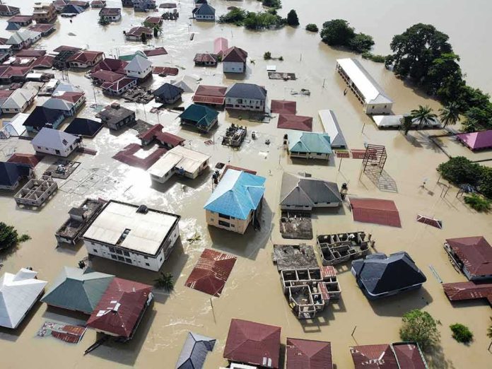
A weakening Tropical Storm Bertha just became the first landfalling storm of the 2026 season, brushing southern Louisiana with dangerous coastal winds and surge instead of the worst-case hurricane nightmare many feared.
Story Snapshot
- Bertha made landfall in St. Bernard Parish, Louisiana, with sustained winds near 45 mph.
- The strongest winds and heaviest rain stayed offshore, but coastal flooding and storm surge still threatened communities.
- Tropical storm warnings and watches stretched from Alabama toward Texas as Bertha moved west along the Gulf Coast.
- Early signs point to limited damage on land, raising fresh questions about how storms are hyped and handled.
Storm Bertha Comes Ashore In St. Bernard Parish
The National Hurricane Center reported that Tropical Storm Bertha’s center made landfall near the Biloxi Wildlife Management Area in St. Bernard Parish, southeast of New Orleans, on Wednesday afternoon. The storm was classified as a tropical storm at landfall, with maximum sustained winds estimated around 45 miles per hour and higher gusts. National and local outlets, including Reuters and AccuWeather, carried the same basic facts, confirming the landfall location and wind speed and marking Bertha as the first United States landfall of the 2026 Atlantic hurricane season.
Different reports gave slightly different times for when Bertha officially came ashore. The National Hurricane Center’s forecast discussion placed landfall “around 2 p.m.” Central time, while public advisories and several media reports cited about 3 p.m. Eastern time. Despite that one-hour gap, all sources agreed on the same stretch of marshy coast in St. Bernard Parish, showing how the place and general timing were clear even if the exact minute would need later technical review.
Main Threats: Coastal Winds, Surge, And Rough Surf
Forecasters warned that Bertha’s biggest danger was not a wall of extreme wind over cities, but a messy mix of gusty winds, coastal flooding, and storm surge along the northern Gulf Coast. The National Hurricane Center said tropical storm conditions would spread westward from Alabama into southwestern Louisiana, including the New Orleans metro area, through Wednesday night and Thursday, with sustained winds of 39 miles per hour or more possible in the warning zones. Swells from the storm were also expected to create life‑threatening surf and rip currents at beaches over several days.
Reports from networks like ABC News and local Louisiana stations backed up this picture of a lopsided storm bringing more coastal nuisance than inland disaster. Meteorologists explained that wind shear had pushed most of the heavy thunderstorms into a band south and southeast of Bertha’s center, over the open Gulf waters. As a result, the strongest winds and heaviest rain stayed offshore, while areas onshore experienced breezy conditions, minor water level rises of one to two feet, and scattered showers rather than widespread flooding.
A Weaker Storm, But Still A Test For Gulf Communities
By the time Bertha hit Louisiana, forecasters described it as weakening yet still fully capable of producing tropical‑storm‑force conditions along parts of the coast. The National Hurricane Center said the storm would continue creeping westward near or along the Louisiana and upper Texas coasts through Thursday, then push farther inland into Texas on Friday, with gradual weakening expected over the next couple of days. Some outlets noted that Bertha could hold on to tropical storm strength into late Thursday, even as its structure became more disorganized over land.
In southwestern Louisiana, the state’s own forecast briefing told residents that impacts were likely to be limited. Officials expected inland wind gusts around 30 miles per hour, with stronger gusts near 40 miles per hour at the immediate coast, plus minor coastal flooding at high tide. Early signs suggested that Bertha would not deliver the kind of major rain or wind event that often knocks out power for days and destroys homes, but emergency managers still urged caution around flooded roads and rough surf as the storm’s outer bands brushed the shoreline.
Why Early Storm Coverage Often Feels Confusing
The mixed messages about Bertha’s timing, intensity, and local impact fit a broader pattern in how storms are reported in the United States. Research on tropical cyclone landfalls shows that forecasters usually nail the landfall area, but short‑term timing errors of a few hours are common, and storms often weaken quickly or keep their worst winds offshore. News outlets then repeat the headline numbers from the National Hurricane Center, such as “45 mile per hour winds,” even when most people on land mainly feel lower gusts and only modest rain.
Flooding in Louisiana after Tropical Storm Bertha makes landfall https://t.co/vbOHmw6Lc2 via @YouTube
— 𝔻𝕆ℕ𝔸 𝐵𝒾𝓁𝓁𝒾𝑒 (@DonaBillie01) July 23, 2026
For many Americans on both the right and the left, this kind of event feeds deeper frustration with how the federal system handles risk and information. People see storm coverage blast warnings across screens, yet follow‑up reporting on real damage, local flooding, and which neighborhoods were truly hit can be thin or late. At the same time, coastal families still must brace, board up, and lose work hours whenever a named storm comes close, even if the final impact turns out minor. That gap between fear and outcome shapes how millions judge government competence and trust in official advisories.
Sources:
washingtontimes.com, accuweather.com, reuters.com, wrbl.com, nhc.noaa.gov, cnn.com, abcnews.com, axios.com, youtube.com, ams.confex.com